A clearcut here, a clearcut there, next thing you know, you’re talking one serious bald spot. That’s what runs through your mind on the way up Annette Lake Trail, especially in the first section, on the north side of the old railroad grade.
- Distance: 7.5 miles, round-trip (out-and-back)
- Elevation:
- High point – 3,600 feet
- Elevation change – 1,400 feet
- Best Season: June-July
The trail begins alongside the Asahel Curtis Nature Trail (Hike 57) but continues to climb to the right when the gentle Asahel Curtis Loop goes left. You’ll follow an ancient old logging road (mostly reclaimed by the fertile forest).
At about 1 mile out, you’ll pass under a high-tension powerline and 0.25 mile later will cross the wide track of the Iron Horse Trail (the old railroad right-of-way). From this point, the trail gets serious. Serious about scenery, and serious about climbing.
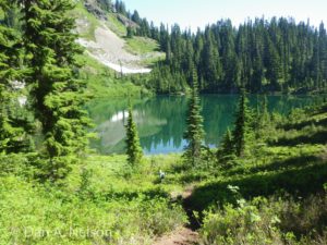
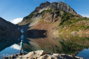
The path switchbacks up the Humpback Creek valley for more than 1.5 miles until the last steep pitch puts you at about 3600 feet elevation. For the next mile, you’ll traverse the slope above Humpback Creek, with occasional views across the valley to Humpback Mountain. The trail ends at the shores of Annette Lake, which lies in the cirque between Humpback Mountain, Abiel Peak, and Silver Peak.
Map Data: Annette Lake Trail (.kml & .gpx track logs)
Directions
From Seattle, drive east on Interstate 90 to exit 47 (Asahel Curtis/Denny Creek). Turn right (south) at the stop sign, then left (north) at the next stop sign. The parking area is in one-half mile. The trailhead is at the east end of the parking lot.
[ngg src=”galleries” ids=”12″ display=”masonry” ngg_triggers_display=”always”]